image by Ivan Sache, 24 May 2010

Last modified: 2021-08-25 by rob raeside
Keywords: san antonio | lima | peru |
Links: FOTW homepage |
search |
disclaimer and copyright |
write us |
mirrors

image by Ivan Sache, 24 May 2010
The district municipality of San Antonio (2,315 inhabitants, 85%
living in urban areas; 3,715 ha) is located 80 km south of Lima, in
the north-western part of the Cañete Province, Department of Lima.
Located on the Pacitic Ocean, San Antonio is crossed by the
Panamerican Road (southern branch).
Made an annex of Mala on 25 September 1921 by Law No. 505, San Antonio
was erected a district on 21 December 1922 by the Congress, which was
confirmed on 17 February 1923 by Law No. 4611; the district includes
the settlements of San Antonio (capital), San Andrés, La Laguna,
Barranco, El Monte, El Pino, Esquivilca, La Dacha, Nuevo San Antonio
and Puerto Viejo.
The district was named for its patron saint, St. Anthony of Padua. In
1769, the local governor Nicolás Avila Manco Rimanchi Yupanqui Quispe
travelled to Spain to plead at the Council of Indies the cause of the
village, threatened by the neighbouring settlement of Chilca;
manhandled by soldiers, he invoked St. Anthony who interceded on his
behalf with the king. The local tradition, however, says that the
early settlement was named for a geological formation recalling the
silhouette of a praying Franciscan friar.
Source:
Municipal website, historical account
Ivan Sache, 24 May 2010
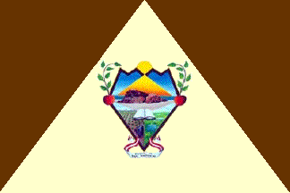
The flag of San Antonio was designed by Rosa Chumpitaz Ramos, the
winner of the contest organized in 2003 by the municipal administration.
The flag, with proportions 2:3, is divided into three triangles, the
two outer, brown triangles converging at the apex of the central,
cream-colored triangle. The municipal shield is placed on the white
triangle
The brown triangles represent the mountains surrounding San Antonio.
The cream-coloured triangle represents peace and tranquillity.
Brown and cream are the traditional colours of San Antonio, recalling
the traditional colours of St. Anthony.
Source:
Municipal website,
description of the flag
The shield of San Antonio was designed by Félix Alberto Ramos Francia,
the winner of the contest organized in 2003 by the municipal
administration.
The shield, of rhomboid shape, has a brown border. Its upper, serrated
edge represents the mountains, over which the sun rises. The lateral
apices of the rhomb are each charged with a leaved branch of the
famous San Antonio apples. The base of the shield bears a scroll in
the national colours (red-white-red) with the writing "DISTRITO DE /
SAN ANTONIO" in brown letters.
The shield is divided into three parts. The upper part shows the
"Sleeping Lion", a rocky natural monument located on the San Antonio
"ecological beaches" visited every year by thousands of tourists and
lit by the sun and the azure sky. The lower left part represents a
cultivated field, symbolizing the local products of agriculture -
grapes, apples, peaches, bananas and olives; grapes are highlightes
with the representation of a bunch of grapes and two bottles of wine
and pisco (the national brandy). The lower right part represents the
wet areas ("humedales") of Puerto Viejo and their natural resources -
flora, fauna and water -, declared a protected area on 18 January 1995
by the municipal council.
The book placed in the middle of the shield represents the Bible and
the Roman Catholic faith, but also knowledge, wisdom and culture.
The whole shield illustrates some mottos associated with San Antonio,
such as "Cradle and capital of apples" (which were brought back from
Spain by Nicolás Avila Manco Rimanchi Yupanqui Quispe), "The ecologic
beaches' district" or "The district with the nice countryside and the
beautiful landscapes".
Sources:
Municipal website,
description of the shield,
presentation of the local apples,
presentation of the "Sleeping Lion",
presentation of the wine and pisco industry,
presentation of the Porto Viejo "humedales"
Ivan Sache, 24 May 2010